Showing posts with label Rhyolite. Show all posts

Friday, August 14, 2015

Feeling Alive in Death Valley


Of all the places we visited during our week in Vegas, Death Valley was my favorite, even better than the Grand Canyon. I fell in love with the place.

We had saved Death Valley for the last day of our trip, knowing it would be a lot of driving (it turned out to be less than going to the Grand Canyon). I've already described the first part of the day in my earlier post about Rhyolite, so we'll pick up from there.

The Death Valley National Park website has a great downloadable pdf of driving routes from Las Vegas, so you can choose if you want to take the shortest route, the most scenic, etc. We chose to make our outward journey along the Ghost Town Route (taking in Rhyolite) and then return via the route listed as the most scenic.

From Rhyolite, we continued driving on NV Hwy 374, across the state line into California and into Death Valley. As the mercury rose, miles of flat lay before us.

Harmony Borax Works.
At Hell's Gate, we took a left onto the Beatty Cut-off Road. I couldn't help but notice that the few other cars on the road all continued on 374. Did they know something we didn't?

A few miles further and we noticed some ruins a little way off the road. We ignored the climbing temperatures; we were here to explore, and so explore we did. Harmony Borax Works was in operation from 1883-1888. Borax was "the gold of Death Valley". I shuddered to imagine how they managed the heat (which by now was about 113 Fahrenheit) as they worked.

Once pulled by a 20-mule team to transport borax.
Speaking of the heat, I was ridiculously excited about it by this point, insisting that we take a picture of the temperature reading every time it climbed a degree. After all, I didn't know how hot it would get and I didn't want to miss that all-important reading. Don't worry - I won't bore you with EVERY degree.

Soon we reached Furnace Valley Visitor Center, where we refilled every water bottle in the car, using the handy-dandy refill fountains, browsed the visitor center, and bemoaned the lack of spoons. My mother collects them and they are becoming increasingly difficult to find - National Parks, take note!

Not the highest.
By this point we were getting rather hungry. The Visitor Center directed us to a campsite a mile or so down the road, complete with golf course, play area, souvenir shop (spoon!) and diner. Although puzzled to find that, even in the height of summer, the diner had a soup of the day, we enjoyed our sandwiches and fries before continuing on our way, now following the directions back to Vegas via the "most scenic route".

Once we got back in the car, I resumed my habit of taking pictures of every view. Every few feet or so, I would insist we pull over so I could photograph the miles of nothing.

And then, there it was. The magical 120 Fahrenheit.
But no, still hotter it became.
No longer able to get any reception on our phones, we were relying on the car's dash for outside temperature readings.

And since you're no doubt dying to know how hot it got that day, here you are...

122 degree Fahrenheit. 

Ladies and gentlemen, I give you 122 degrees!

It's kinda warm!

But back to Death Valley and the scenery.

Now here's the part that puzzled me. We were on Badwater Road when we saw the sign noting the turn-off to the Artist's Palette. I knew from reading up that this was the scenery we really wanted to see - a colorful blend of mineral-soaked rocks. But the few other cars on the road bypassed it completely. How often do you get to see this?

Artist's Drive took us on a looping tour through the beautifully-colored rock formations. Words can't do them justice, and the changing position of the sun must surely mean that they always look different. I'll simply share some photos.

Artist's Palette
The layers of minerals include iron, aluminum, magnesium, titanium, red hematite, green chloride, and more. Magnificent.

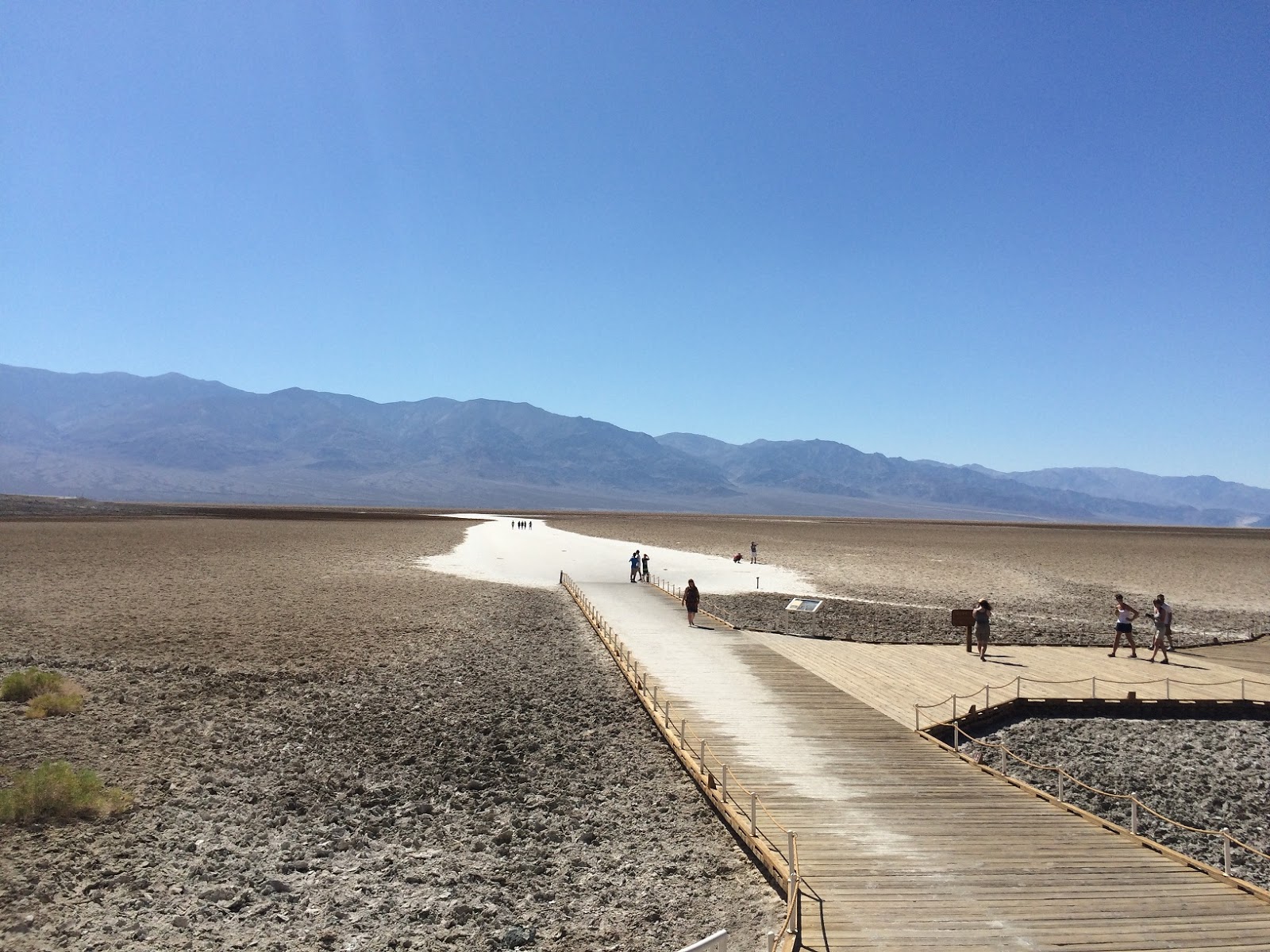
Once we rejoined the main road, we continued on to Badwater Basin, which holds the distinction of being the lowest spot in North America - 282 feet (855 meters) below sea level. For trivia fans, Mount Whitney, the highest spot in the contiguous 48, is just 84 miles away.

Spot the Sea Level Marker - yes,
I've circled it to make it easier for you!


We emerged from the air-conditioned car to walk along the platforms by the delicate salt flats, and this is where the heat really started to feel intense.

Have you ever been somewhere so hot that you feel as if you are standing in front of an open oven door?

Somewhere so hot, that your hands are actually cooler when you put them IN your pockets because that removes them from the blasting dry heat?

I have now.

Even with plenty of water, after a few minutes I could feel my throat tightening from the heat. The air was so dry that all moisture evaporated immediately.

I had finally met my match.


Badwater Basin

Wooden platforms protect the delicate salt flats.
This is not the sort of place where you want your car to break down or where you want to be caught without water, hence our multiple bottles, all carefully refilled at Furnace Valley. While we're on the subject of your car breaking down, a few miles later we were worried that we may be developing a flat tire. The alarm light went off and I had visions of us needing to do a change in the infernal heat (I've always wanted to use that phrase!) Several checks showed no apparent problems with the tires, and we can only conclude that the extreme temperatures were confusing the gauges and the pressure sensors.

On we drove, and eventually we reached the edge of Death Valley, and signs of civilization. By civilization, I mean Shoshone, California, population: 31.

If you were low on gas, this was your opportunity to fill up, for the princely sum of $5.50 a gallon. To be fair, this was miles from anywhere so the simple law of supply and demand was in evidence, although I suspect there may have been a cheaper, unadvertised rate for locals.

St. Therese Mission, Tecopa, CA.
From Shoshone to Tecopa, a comparative boomtown with a population of 150 but lacking a gas station or grocery store. For those items, Shoshone had captured the market. Tecopa is home to some natural hot springs which apparently attract quite a few visitors. At Tecopa, we joined the Old Spanish Trail, which would lead us back into Nevada to Hwy 160. This part of the drive was largely uneventful (despite signs promising what appeared to be happy dancing cows and deer). We did, however, pass the St. Therese Mission just outside Tecopa, and note what appeared to be a dust storm moving through the valley.

Dust sweeps through the valley.
That evening in Vegas - a balmy 102 degrees - I found myself feeling a little chilly. I guess the heat had got to me, in more ways than one.

Death Valley was, without a doubt, my favorite part of the trip. It is a beautiful wilderness and experiencing it in such heat, it is almost unfathomable how people made their livelihoods out here. But they did, as the ruins of Rhyolite show. And they still do, as is evidenced in Shoshone and Tecopa. And back in the humidity of Kentucky the next day, I found myself uncomfortably sweaty and missing the dry heat of the desert.

Drops of water in the salt flats at Badwater
A long-dried river bed near the Artist's Palette


Death Valley: Land of Extremes
More spectacular colors at Artist's Palette


The obsessive photographer


Tuesday, August 4, 2015

Desert Mining Towns Part 2 - Rhyolite, NV

Yesterday, I wrote about the former mining town of Chloride, AZ, now a quirky community with gunfights for tourists at weekends.

Today I want to look at another former mining town that we visited during our trip to Nevada, this one now a skeleton of its former self, and just a few miles from Death Valley National Park. Just as Chloride was named for the mineral mined there, so Rhyolite was a source of its titular mineral, as well as gold and quartz. But I'm getting ahead of myself... first the drive there.

Long, empty road.

To reach Rhyolite, we followed the directions given on the Death Valley NP site, following the long road to Beatty and then turning toward the park. The drive itself was not particularly remarkable, save for the reminders that we were in Nevada, where brothels are legal. My favorite roadside billboard (which sadly I did not take a picture of) proudly advertised: BROTHEL - Hot Sauce, Pictures, Souvenirs. 

Hot sauce - who knew!
The gas station where we stopped also sold a variety of Bunny Ranch souvenirs.

We didn't stop in Beatty, although we later learned that it is home to a huge candy store, one of the biggest in the state, thanks to a local entrepreneur with a sweet tooth. 

On the road from Beatty to Hell's Gate, in one of the most desolate places you can imagine, there is a road that turns off to the remains of Rhyolite, paved in spots, gravel in others. Follow that a little way and turn off to the left toward Bullfrog. One more left turn down a gravel road brings you to the Rhyolite/Bullfrog cemetery (Did you think I'd skip it?) 
Cemetery


The cemetery is home to some 280 graves, although the majority of them are unmarked or marked only by a simple pile of rocks.
A monument marks the historical significance of the site, and there are a few more recent graves.

A few older ones have stone markers, which are still legible. They offer a glimpse into the miners who settled the town, people such as Daniel Kennedy, who traveled from Nova Scotia to

Grave of Daniel Kennedy
Bullfrog, presumably to find his fortune. Daniel died at the tender age of 21.

Other graves, even if once marked, were now worn away to - if lucky - a faded wooden slab, the occupants' names and stories lost to the mists of time.

Rocks outline the two graves marked by this more recent stone.

Some old graves have wooden barriers around them...
Details lost to the ravages of the desert air.

Wandering around the burial ground was a profoundly peaceful experience, but one with an enormous sense of isolation. Hot winds blew across the rocky desert. Seeing mounds of gravel that had never settled lay scattered in seeming random positions. If I closed my eyes, I could almost imagine the far off sound of mining tools.

Leaving the cemetery and heading back toward Rhyolite, we could see the ruins of buildings, and something else...very unexpected.

Silhouetted against the starkness of the skyline were figures - tall, white, hooded. 


The Last Supper
The Goldwell Open Air Museum is an unexpected find at the edges of a ghost-town. At the same time, the sculptures add to the eeriness.

The Last Supper and several other ghostly works are by Belgian artist Albert Szukalski. According to the museum brochure, the figures were cast by using models draped in fabric which was then soaked in layers of plaster. As the plaster set, the model slipped out, leaving the shell behind. The sculptures were then coated with fiberglass to protect them from the weather.

Ghost Rider
In addition to those pieces by Szukalski, the museum contains pieces by several other Belgian artists, all of whom made their home in this unlikely location during the 1990s. Now, their work makes up possibly the most unique art museum I've ever visited.


From the Goldwell, it's a short drive to Rhyolite. 

Ryolite was born in 1905 and quickly attracted those determined to find their fortune in gold. At first, Bullfrog was a competing camp, and the two struggled against each other to become the primary settlement. Rhyolite won and by 1906, the last merchant had quit the neighboring camp.

In the frenzied days of the Gold Rush, thousands of claims were made in the area, and growth of the town was rapid. The town boomed, having close to 10,000 residents within a year or two. Railroads, banks, an opera house, a stock exchange, more than a dozen restaurants, churches, 40 saloons - Rhyolite was civilization in the middle of nowhere. Of course, there was also a red light district, with seven brothels available to provide comfort to those lonely miners. 

Rhyolite
Rhyolite's decline was as swift as its rise. After the 1906 San Francisco earthquake, investment slowed. Some investors claimed they had been tricked into buying shares. In 1911, the town newspaper declared that the main mine, the Montgomery-Shoshone, was dead. The newspaper went out of business two weeks later. The editor wasn't the only one to leave town. The population of 7,523 in 1910 had shrunk to a few hundred within a year. In 1920, only 14 people remained. The last person left in the 1960s, moving to nearby Beatty.

Many of the buildings were moved or torn down and strippped for materials. Today, as the pictures below show, just a few shells are all that remain of the once-booming gold town. 

As the sign in the window says - BROTHEL

Remains of the school and a bank. By the time the school was completed, the town was already in decline.


The former railroad depot
Main(e) Street 

The Tom Kelly house. Seventy-six year old Tom Kelly spent five months building this house between 1905 and 1906. More than 30,000 bottles were used to construct the walls. Once completed, he raffled off the house.
All that's left of Rhyolite